The Donn V. Hart Southeast Asia Collection includes a collection of about 50 rare maps of Southeast Asia, produced from 1500s to 1800s. These maps can be viewed onsite in the Reading Room of the Rare Books and Special Collections, located on the 4th floor of the main library.
-------------------------------------------------------------------------------------------------------------------------------------------------------------------
Maps of Southeast Asian (the region)
- Aa, Pieter van der, 1659-1733. : Scheeptogt onder den Ammiraal Wybrand Van Warwyk,van Bantam na China Gedaan. Lieden : [Aa?, 172-?]. Call number: G 8000 1720z .A12

- Clüver, Philipp, 1580-1622. Indiae Orientalis et Insularum Adiacentium Antiqua et Nova Descriptio. [Wolfenbüttel? : Per I Bunonem?, 1667?]. Call number: G 8000 1667 .C58
Note: From Cluver'sIntroductionis in Universam Geographiam tam Veterem Quam Novam, 1667.

- Indes Orientales, ou du Gange. [ S.l. : s.n., 16--?]. Call number: G 7625 1600z .I52

- Kitchin, Thomas, d. 1784. An Accurate Map of the East Indies, From the Latest Improvements and Regulated by Astronomical Observations. [London? : R. Sayer & J. Bennett?, 177-?]. Call number: G 7625 1770z .K57

- Ptolemy, 2nd cent. India Orientalis. . . [Colonia : P. Keschedt, 1608]. Call number: G 7401 .S2 1608 .P78
Notes : From Ptolemy's (?)Geographiae Universae, 1608.
In the lower right corner: Coloniae formulis Jani Buxmacheri, 1600.
This map is formed from two sheets of paper seamed together. There is text in Latin about India on the verso.

- Ptolemy, 2nd cent. : Tabula Asiae XI. [Venetia : Appresso Vincenzo Valgrisi, 1561]. Call number: G 7626 .S2 1561 .P76
Notes : Revised and edited by Girolamo Ruscelli. From Valgrisi'sLa Geografia di Claudio Tolomeo, 1561.
This map is formed from two sheets of paper seamed together. There is text in Latin on the verso.

Maps of Burma
- Bellin, Jacques Nicolas, 1703-1772.Carte du Golphe de Bengale. [Paris : Bellin, 1764]. Call number: G 7652 .B4 1764 .B45
From Bellin's Le Petit Atlas Maritime, 1764.

- Bellin, Jacques Nicolas, 1703-1772. Port et Bourg de Mergui. Paris: [Bellin], 1764. Call number: G 7724 .M4 1764 .B45
From Bellin's Le Petit Atlas Maritime, 1764.

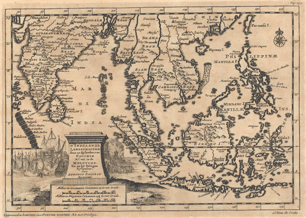
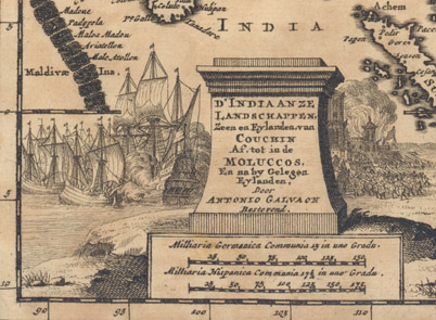
- Galvao, Antonio D. D'India anze Landschappen
Leyden, 1729 [Detail]. Call number: G 8000 1729 .C35
- Mercator, Gerhard, 1512-1594.India Orientalis. [Amsterdam : Ianssen, 1630]. From his Atlas minor, 1630. Call number: G 7400 1630 .M47
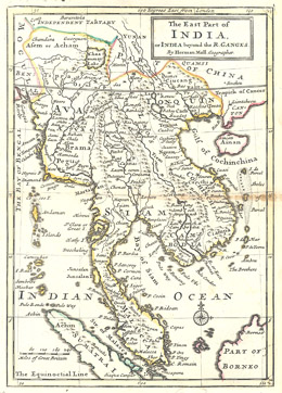
- Moll, Herman. The East Part of India, or, India Beyond the R. Ganges. London, 1729. Call number: G 8005 1730 .M65
- Ptolemy, 2nd cent. [ASIA] [4 Maps]
Douay?, 1605? Call number: G 7401 .S2 1605 .P78
This map features four separate maps on one sheet.
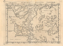
- Ptolemy, 2nd cent. India Tercera Nuova Tavola. [Venetia: Appresso Vincenzo Valgrisi, 1561]. Call number: G 8001 .S2 1561 .P76
Notes : From Valgrisi'sLa Geografia di Claudio Tolomeo, 1561.
This map is formed from two sheets of paper seamed together. There is text in Italian on the verso on "India Tercera."
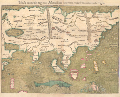
- Ptolemy, 2nd cent. Tabula orientalis regionis, Asiae scilicet extremas complectens terras & regna. [Basiliae: Apud Henricum Petrum, 1540]. Call number: G 7401 .S2 1540 .P76
This map was scanned in two sections and pieced together.
- Seutter, Matthaeus, 1678-1756.Asia, cum omnibus imperiis provinciis,statibus et insulis, correcta et adornata per Mattaeum Seutter. Augsburg : Tobias Conrad Lotter,[1744]. Call number: G 7400 1744 .S48

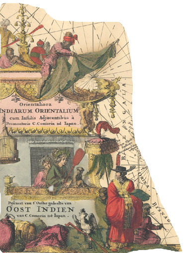
- Goos, Pieter.Pascaert van t'ooster gedeelte van Oost Indien van C. Comorin tot Iapan. [S.l. : s.n., 165-?]. Call number: G 8001 .P5 1650z .C66

Detail
Maps of Indonesia
- Aa, Pieter Vander, 1659-1733. De Moluccos, of Speceri-dragende eilanden tussen Gilolo en Celebes gelegen. Leide : Aa, [1714?]. Call Number: G 8130 1714 .A12.

- Aa, Pieter Vander, 1659-1733. La Rade de Bantam, Dressee sur les Observations des Meilleurs Geographes. Leide : Aa, [1729]. Call Number: G 8074 .B33 1729 .A12
From Aa's La Galerie Agréable du Monde, 1729.
- Bellin, Jacques Nicolas, 1703-1772. Batavia Assiece en 1629 / Batavia A°.: 1629 Belegerd. [Paris? : Bellin?, 175-?]. Call Number: G 8074 .D3 1629 .B45
Notes : Engraved by J. V. Schley.
The pictorial map is of Batavia in 1629, but published by Bellin over a century later.

- Bellin, Jacques Nicolas, 1703-1772. Carte de l'Isle Celebres ou Macassar, pour Servir a l'Histoire Generale des Voyages. [Paris? : Bellin?, 175-?] Call Number: G 8110 1750z .B45

- Bellin, Jacques Nicolas, 1703-1772. Carte Particuliere de l'Isle d'Amboine/Byzondere Kaart van het Eyland Amboina. [Paris? : Bellin, 175-?]. Call Number: G 8132 .A6 1750z .B45

- Bellin, Jacques Nicolas, 1703-1772. Carte des Environs de Batavia, Tiree des Hollandois. [Paris : Bellin, 176-?]. Call Number: G 8074 .D3 1760z .B45.
From Bellin's Le Petit Atlas Maritime, 1764.
- Bellin, Jacques Nicolas, 1703-1772. Carte Particuliere des Isle Moluques. [Paris : Bellin, 1764]. Call Number: G 8130 1764 .B45
From Bellin's Le Petit Atlas Maritime, 1764.

- Bellin, Jacques Nicolas, 1703-1772. Isle de Baly / 'T Eiland Baly. [Paris? : Bellin?, 175-?]. Call Number: G 8072 .B3 1750z .B45.
Notes : Inset shows "Plan d'un Palais du Roi."
Engraved by J.V. Schley.

- Bellin, Jacques Nicolas, 1703-1772. Isle de Machian / 'T eyland Makjan ;Isle de Bachian / 'T eyland Batsjan. [Paris : Bellin, 1750?]. Call Number: G 8132. M3 1750 .B45.

- Bellin, Jacques Nicolas, 1703-1772. Isles de Banda = Eylanden van Banda. [Paris? : Bellin?, 1750?]. Call Number: G 8132 .B4 1750 .B45

- Bellin, Jacques Nicolas, 1703-1772. Plan de l'isle Onrust / Grondtékening van 't eiland Onrust. [Paris : Bellin, 1750?]. Call Number: G 8092 .O5 1750 .B45.
Note: A small island in the bay of Jakarta.
- Bellin, Jacques Nicolas, 1703-1772. Ternate. [Paris? : Bellin?, 175-?]. Call Number: G 8132. T4 1750 z .B45
Includes Dutch and French index to numbered sites.
This is a bird's eye view of the city from the sea.

- Bonne, Rigobert, 1727-1794. : Carte des isles de la Sonde et des isles Moluques. [Neuchâtel : Chez le Librairies Associés, 1783]. Call Number: G 8070 1783 .B65
From G.T.F. Raynal's Atlas de Toutes les Parties du Globe Terrestre, 1783-1784.

- Dower, John, fl. 1838-1846?. East India Islands. London : Orr, [185-?] Call Number: G 8070 1850 .D68

- Le Rouge, Georges-Louis. Isles de la Sonde. Paris : Chez Crepy, [1767?]. Call Number: G 8070 1767 .L42
From Le Rouge's (?)Atlas Nouveau Portatif à l'usage des Militaires, Collèges et du Voyageur, 1767-1773.

- Le Rouge, George-Louis. Isles Moluques. [Paris : Le Rouge, 1756?] Call number: G 8130 1756 .L47
From Le Rouge's Atlas Nouveau Portatif à l'usage des Militaires, Collèges et du Voyageur, 1756-1759.

- Philippe de Prétot, Etienne André, d. 1787. Plan de la Rade de Batavia. [Paris : Nyon l'ainé, 1787]. Call Number: G 8092 .C6 P5 1787 .P45
- Sayer, Robert, Bennett, John. A chart of the north coast of Java wherein are described the roads of Bantam and Batavia. [London : Robt Sayer & Jn Bennett, 1778]. Call Number: G 8092 C6 P5 1778 S39

- Jansson, Jan. Insulae Iavae, cum parte insularum Borneo, Sumatrae et circumjacentum insularum novissima delineatio. [Amsterdam : Jansson, 1657?]. Call Number: G 8090 1657 J3.

- Aa, Pieter van der. ’T koninkryk Sunda met dat van Iava. [Leide : Aa, 172-?]. Call Number: G 8090 1790z A12.

- Chatelain, Henri Abraham. Carte de l’ile de Java. [Amsterdam : Honoré & Châtelain, 1719?]. Call Number: G 8090 1719 C47

- Gregory, Henry. Island of Java. [London? : Gregory?, 1787?]. Call Number: G 8091 P5 1787 G74

Maps of Malaysia
- Bellin, Jacques Nicolas, 1703-1772. Plan de la Ville et Forteresse de Malaca Pour Servir a l'Histoire Generale des Voyages / Grondtekening van de Stad en Vesting Malakka, om Te Deinen Voor de Hist. Beschr. der Reizen. [Paris : Bellin], 1750. Call number: G 8034 .M35 1750 .B45
From Bellin's Le Petit Atlas Maritime?, 1764
There are ink smudges of words and one side of the map appears as if it was torn out of a book.

Maps of the Philippines
- Bellin, Jacques Nicolas, 1703-1772. Carte des isle Philippines, Celebes et Moluques. [Paris : Bellin, 1764]. Call Number: G 8060 1764 .B45
From BellinLe Petit Atlas Maritime, 1764
Tome III, No. 64.
- Bellin, Jacques Nicolas, 1703-1772. Carte des isles Philippines : dressée sur la carte espagnole du R.P. Murillo de Velarde. [Paris : Bellin,1764] Call number: G 8060 1764 .B44
From BellinLe Petit Atlas Maritime, 1764
Tome III, No. 65-66. The top map (northern portion) is No. 65 and the lower map is No. 66.

- Bellin, Jacques Nicolas, 1703-1772. Plan de la baye de Manille située dans l'isle de Luçon. [Paris : Bellin, 1764]
From Bellin Le Petit Atlas Maritime, 1764. Call Number: G 8062. M3 P5 1764 .B45
Tome III, No. 67.

- Bonne, Rigobert, 1727-1794. Les isles Philippines, celle de Formose, le sud de la Chine, les royaumes de Tunkin, de Cochinchine, de Camboge, de Siam, des Laos, avec partie de ceux de Pegu et d'Ava. [Neuchâtel : Chez les Librairies Associés, 1783?]. Call Number: G 8000 1783 .B65
Note : From G.T.F. Raynal'sAtlas de Toutes les Parties Connues du Globe Terrestre, 1783-1784.

Maps of Thailand
- Bellin, Jacques Nicolas, 1703-1772. Carte du Cours du Menan, Depuis Siam jusqu'a la Mer. [Paris : Bellin, 1764]. Call Number: G 8027 .C47 1764 .B45
From Bellin's Le Petit Atlas Maritime, 1764.

- Bellin, Jacques Nicolas, 1703-1772. Plan de la Ville de Louvo, Demeure Ordinaire des Rois de Siam.[Paris : Bellin, 1764]. Call Number: G 8029 .L6 1764 .B45
From Bellin's Le Petit Atlas Maritime, 1764.

- Bellin, Jacques Nicolas, 1703-1772. Ville de Siam, ou Juthia. [Paris: Bellin, 1764]. Call Number: G 8029 .U8 1764 .B45
From Bellin's Le Petit Atlas Maritime, 1764.

Maps of Vietnam
- Bellin, Jacques Nicolas, 1703-1772. Carte du Cours de la Riviere de Tunquin depuis Cacho jusqu'a la Mer: Levee par un Navigateur Anglois. [Paris : Bellin, 175-?]. Call Number: G 8022 .T62 1750z .B45
- Bellin, Jacques Nicolas, 1703-1772. Carte du Cours de la Riviere de Tunquin depuis Cacho jusqu'a la Mer: Levee par un Navigateur Anglois. [Paris : Bellin, 1764]. Call Number: G 8022 .T62 1764 .B45
Although similar to the map above, there are differences in the detail of the relief shown and this map is hand colored. The scales are different and the 1764 map includes a cartouche.